Protect Our Water and Environment
Karst Terrain and Aquifers in Minnesota
Introduction
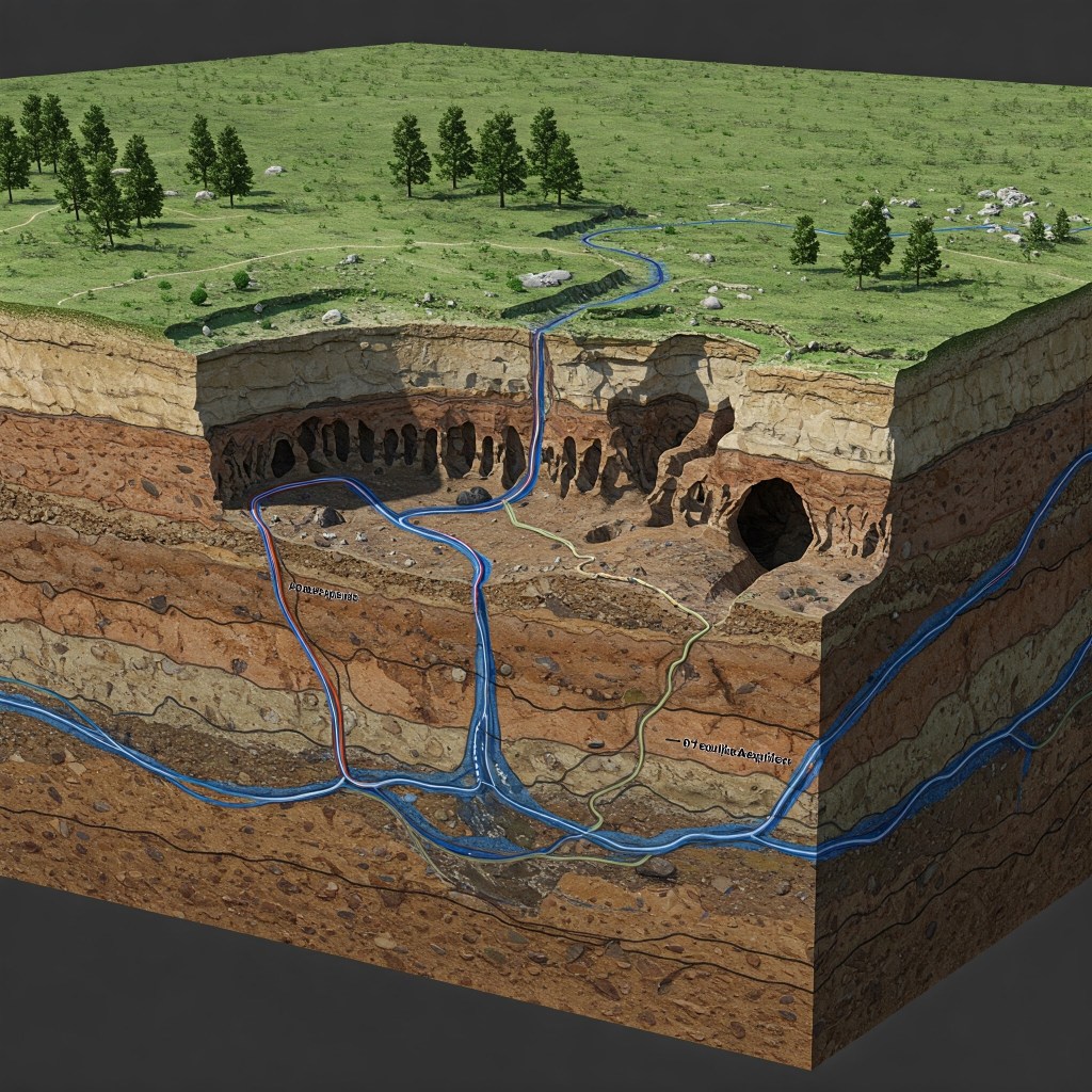
Karst terrain is a distinctive geological landscape primarily formed by the dissolution of soluble rocks like limestone and dolomite. This process, driven by slightly acidic water over long geological periods, creates features such as sinkholes, caves, springs, and disappearing streams. Within this terrain, Karst aquifers develop. Unlike typical aquifers where water flows through small pore spaces, Karst aquifers feature groundwater moving through enlarged fractures, joints, and conduits created by dissolution. This results in unique hydrogeology characterized by rapid, sometimes turbulent flow and heightened vulnerability to contamination. Understanding Karst systems is crucial for water resource management, especially in Minnesota where they are a significant source of water but are also easily polluted.
Understanding Karst: Terrain vs. Aquifers
- Defining Karst Terrain:
- Karst terrain is a distinctive landscape shaped primarily by the dissolution of soluble rocks, most commonly limestone and dolomite 1. These rocks, composed mainly of calcium carbonate and calcium magnesium carbonate, are susceptible to being dissolved by slightly acidic water over extended periods 3. The acidity in rainwater increases as it passes through the soil, absorbing carbon dioxide 4. While limestone and dolomite are the principal rock types associated with Karst, other soluble rocks like gypsum and evaporites can also contribute to its formation, although these are less prevalent in the context of Minnesota 5. This chemical weathering process results in a suite of characteristic geological features that define Karst terrain. These include sinkholes (also known as dolines), caves, springs, disappearing streams, and underground drainage systems 1. These surface expressions are direct consequences of the subsurface dissolution processes, indicating an integrated hydrological system where surface water and groundwater are closely connected 14. The development of these landscapes is a slow geological process, often taking millions of years to form the intricate networks of underground conduits and the distinctive surface topography 3.
- Defining Karst Aquifers:
- A Karst aquifer is specifically an aquifer that exists within Karst terrain, where the dissolution of the soluble bedrock has created significant porosity and permeability 1. This enhanced permeability allows for the storage and transmission of substantial quantities of groundwater. Karst aquifers are characterized by a unique hydrogeology that distinguishes them from other types of aquifers. They are known for their high productivity due to the presence of large, interconnected conduits that facilitate rapid water flow 1. This efficient flow system can lead to high well yields and significant spring discharges, making them important sources of water in regions where they occur. However, this same characteristic also makes Karst aquifers extremely vulnerable to contamination 1. The direct and rapid pathways from the surface to the groundwater mean that pollutants can quickly enter the aquifer with little natural filtration. Groundwater flow in Karst aquifers is often characterized by rapid conduit flow, with water moving at speeds that can reach miles per day through the solution-enlarged openings 10. This rapid movement has significant implications for the transport of contaminants and the responsiveness of springs to precipitation events. The close interaction between surface water and groundwater is another defining feature, with surface streams potentially losing water to the subsurface and groundwater emerging at springs, further emphasizing the interconnectedness of the hydrologic system 4.
Karst Distribution in Minnesota
- Southeastern Minnesota: The Primary Karst Region
- The southeastern corner of Minnesota is widely recognized as the primary region within the state where Karst terrain is prevalent 3. This area is underlain by Paleozoic carbonate bedrock, including limestone and dolostone formations that are at or near the surface in many locations 3. Specific geological groups and formations contributing to the Karst landscape include the Cedar Valley Group, Prairie du Chien Group, Galena Group, Dubuque Formation, Shakopee Formation, Oneota Dolomite, Cummingsville, and Platteville formations 3. The presence of these soluble rock units, combined with hydrological conditions conducive to dissolution, has led to the development of extensive Karst features across several counties in southeastern Minnesota. These counties include Fillmore, Houston, Winona, Olmsted, Goodhue, Mower, Wabasha, Dodge, Rice, and Dakota 3. Fillmore County is particularly notable for its high density of Karst features, earning it the nickname of the “sinkhole capital” with an estimated 10,000 sinkholes in the county 3. The visible Karst features in southeastern Minnesota are diverse and include numerous sinkholes, such as those around the town of Fountain, as well as caves like Mystery Cave and Niagara Cave 13. Springs are also common, with examples like Big Spring and the artesian springs at the Lanesboro DNR Fish Hatchery, which are sustained by the Karst hydrology of the area 13. Disappearing streams, where surface water flows into underground openings, are another characteristic feature of this landscape 13. The Minnesota DNR maintains the Karst Feature Inventory (KFI), a database that maps and documents these surface Karst features, highlighting the state’s recognition and study of this terrain 12.
Other Areas: Other Potential Karst Regions in Minnesota - While southeastern Minnesota is the primary area, Karst terrain, to a lesser extent, is also found in other parts of the state. The DNR indicates that Karst is common in the east-central portion of Minnesota 21. This suggests that while the intensity and extent of Karst features might not be as pronounced as in the southeast, similar dissolution processes have occurred, potentially leading to the development of Karst aquifers. In northwestern Minnesota, carbonate rocks similar to those in the southeast are present, but they are located deep beneath the surface 3. The significant overburden of glacial sediments in this region likely limits the formation of extensive surface Karst features and may influence the characteristics of any underlying aquifers. Interestingly, Karst-like features have also been documented in sandstone formations in Pine County, located in the eastern part of the state 4. This indicates that fractured sandstone can also exhibit characteristics of Karst, possibly due to dissolution within the sandstone itself or the influence of underlying soluble rocks.
Glacial Sediment Influence: Influence of Glacial Sediments - A significant portion of Minnesota is covered by thick glacial sediments deposited during past ice ages 3. These sediments can obscure the underlying Karst landscape, making the surface features less apparent. The thickness of these glacial deposits also plays a crucial role in how Karst terrain and any associated aquifers are classified. The Minnesota Pollution Control Agency (PCA) categorizes Karst lands into three types based on the depth to bedrock: Active Karst, where soluble rocks are within 50 feet of the surface; Transition Karst, with 50 to 100 feet of sediment cover; and Covered Karst, where the bedrock is more than 100 feet deep 4. Surface Karst features are most commonly observed in areas classified as Active Karst, where the bedrock is close enough to the surface for dissolution features to manifest 4. The thickness of the sediment cover can influence the rate of recharge to aquifers, the natural filtration of water, and the overall expression of Karst features at the surface 4.
Identifying Karst Aquifers in Minnesota
Karst aquifers are confirmed in Minnesota, especially in the southeastern region. In Goodhue County, limestones and dolostones are specifically identified as Karst aquifers due to solution-enhanced permeability. Fractured sandstone aquifers (St. Peter, Jordan, Hinckley) in this region also show Karst-like characteristics, suggesting the influence of dissolution extends beyond just carbonate rocks. The Minnesota DNR recognizes a distinct “Karst province” in the southeast due to its unique hydrogeology and vulnerability.
Geological and Hydrogeological Characteristics
- Geology: Primarily composed of soluble carbonate bedrock (limestone, dolostone). Dissolution enlarges pre-existing fractures and bedding planes, creating conduit networks. Less permeable shale layers can influence flow paths.
- Hydrogeology: Characterized by rapid, often turbulent groundwater flow through conduits (potentially miles per day). Recharge occurs via infiltration and direct inflow from sinkholes/disappearing streams. Discharge is primarily through springs, which contribute significantly to streamflow. Springsheds (recharge areas for springs) are important but complex to delineate. Hypogenic Karst (formed by upwelling groundwater) may also occur.
- Vulnerability: High susceptibility to contamination from surface sources (e.g., agricultural runoff, spills) due to rapid flow and minimal filtration. Nitrate contamination is a documented issue in southeastern Minnesota.
Karst in Specific Minnesota Locations
Several cities and townships in southeastern Minnesota are situated within this Karst region, exhibiting related features and relying on potentially vulnerable Karst aquifers:
- Northfield (Rice County): Located in the Karst region, likely overlying the Saint Peter-Prairie du Chien-Jordan aquifer system, known to have Karst features. Spring Creek Park suggests the presence of springs. The Rice County Geologic Atlas is in progress.
- Waterford Township (Dakota County): Within the southeastern Karst region, likely underlain by sedimentary bedrock aquifers (e.g., Prairie du Chien Group) prone to karstification. While specific features weren’t detailed in the source material, sinkhole activity nearby suggests potential.
- Castle Rock (Dakota County): Also in the southeastern Karst region, sharing similar geology and aquifer potential with Waterford Township. Proximity to documented sinkholes suggests potential Karst features.
- Randolph (Dakota & Goodhue Counties): Spans two Karst-prone counties, likely overlying Karst aquifers within formations like the Prairie du Chien and Galena Groups. Proximity to sinkhole areas in both counties and the presence of Chub Creek indicate Karst influence. The Goodhue County Geologic Atlas provides specific data.
- Cannon Falls (Dakota & Goodhue Counties): Situated across both counties in a known Karst area, near the Cannon River Wilderness Area with exposed limestone. Aquifers likely include Prairie du Chien and Galena Groups. Documented features include sinkholes (especially in Goodhue Co.), springs (e.g., Brown Springs), and historical spring use. The Goodhue County Geologic Atlas and a Cannon River Watershed GRAPS report are relevant resources.
- Faribault (Rice County): Located in a Karst area, with Karst topography visible along the Straight River. It relies on the Saint Peter-Prairie du Chien-Jordan aquifer system. Known features include sinkholes, springs, and a stream sink identified near the city. Relevant resources include the in-progress Rice County Atlas, an older Faribault County Atlas, and the Cannon River Watershed GRAPS report.
Confirmation of Existence
The presence of Karst aquifers in Minnesota is confirmed by multiple sources, particularly within the southeastern region of the state where carbonate bedrock is prevalent 1. In Goodhue County, for example, the limestones and dolostones are explicitly identified as Karst aquifers 18. This designation is based on the fact that the primary porosity and permeability of these bedrock units are a direct result of solution-enlarged joints, bedding planes, and conduits – the hallmarks of Karst hydrogeology 18. This aligns with the broader definition of Karst aquifers as water-bearing geological formations where dissolution has significantly enhanced their capacity to store and transmit groundwater.
4.2 Fractured Sandstone Aquifers with Karst Characteristics
Interestingly, fractured sandstone aquifers, specifically the St. Peter, Jordan, and Hinckley Formations found in southeastern Minnesota, also exhibit Karst-like features 4. Sinkholes observed in areas underlain by these sandstone formations are often interpreted as having formed due to the dissolution of underlying dolostone, indicating a strong influence of Karst processes even in non-carbonate rock types 23. This suggests that the concept of Karst aquifers in Minnesota may extend beyond traditional carbonate rock aquifers to include other geological formations where dissolution plays a significant role in their hydrogeological properties.
4.3 Groundwater Provinces
The Minnesota DNR has designated a “Karst province” (Province 3) in the extreme southeast of the state as part of its classification of groundwater provinces 21. This province is characterized by thin or absent sediment cover, making the underlying productive bedrock aquifers particularly susceptible to impacts from land-surface activities 26. The recognition of this distinct Karst groundwater province by the state’s natural resource agency underscores the importance and unique hydrogeological characteristics of aquifers in this region.
5. Geographical Location of Minnesota Karst Aquifers
The primary geographical location of identified Karst aquifers in Minnesota is within the southeastern counties, including Fillmore, Houston, Winona, Olmsted, Goodhue, Mower, Wabasha, Dodge, Rice, and Dakota 3. Within these counties, the Karst aquifers are hosted within specific carbonate rock formations such as the Prairie du Chien Group, Galena Group, Dubuque Formation, Shakopee Formation, Oneota Dolomite, Cedar Valley Group, Cummingsville, and Platteville formations 3. The fractured sandstone aquifers (St. Peter, Jordan, and Hinckley Formations) that exhibit Karst characteristics are also located in this southeastern part of the state 4. Resources like the Minnesota Karst Feature Inventory (KFI) and the Minnesota Regions Prone to Surface Karst Feature Development map, both maintained by the DNR, provide valuable tools for visualizing the distribution of Karst features and, by extension, the potential locations of the underlying Karst aquifers 12.
6. Geological Characteristics and Hydrogeology of Minnesota Karst Aquifers
6.1 Geological Composition
The primary geological component of Minnesota’s Karst aquifers is the soluble carbonate bedrock, consisting of limestone and dolostone 3. Limestone is primarily composed of the mineral calcite (calcium carbonate), while dolostone is mainly composed of dolomite (calcium magnesium carbonate) 3. The dissolution of these minerals by slightly acidic groundwater is the fundamental process driving Karst development 3. Pre-existing geological discontinuities within the bedrock, such as fractures, joints, and bedding planes, serve as the initial pathways for groundwater flow and the onset of dissolution 12. Over time, the continued flow of water enlarges these openings, eventually forming the interconnected network of conduits that are characteristic of Karst aquifers 12. Within the geological sequence of southeastern Minnesota, less permeable shale layers are also present 15. These shale layers can act as barriers to vertical groundwater flow, influencing flow patterns and potentially creating zones where younger, shallow groundwater mixes with older, deeper water 15.
6.2 Hydrogeological Behavior
A defining characteristic of Minnesota’s Karst aquifers is the rapid flow of groundwater through the interconnected conduit systems 10. Flow velocities can be remarkably high, reaching several miles per day, which has significant implications for both water availability and the potential for rapid contaminant transport 10. In the shallow carbonate aquifers of southeastern Minnesota, groundwater flow is often turbulent due to the large size of the conduits and the high flow rates 23. This contrasts with the more laminar flow typically observed in porous media aquifers. Recharge to these Karst aquifers occurs through several mechanisms, including the infiltration of precipitation through the often thin soils overlying the bedrock, direct inflow from sinkholes and disappearing streams, and potentially from adjacent aquifers 10. This direct connection to surface water sources contributes to the rapid response of Karst aquifers to precipitation events. Groundwater in Karst aquifers primarily discharges through springs, which can be significant sources of streamflow in the region 1. Examples include Big Spring and the springs supplying the Lanesboro Fish Hatchery 13. The concept of springsheds is important in Karst terrain, representing the land area that contributes to the discharge of a particular spring 12. Delineating these springsheds can be complex due to the intricate underground flow pathways characteristic of Karst systems. Finally, the phenomenon of hypogenic karst, where caves and other dissolution features are formed by upwelling groundwater from deeper sources, may also play a role in the hydrogeology of some Karst aquifers in southeastern Minnesota, with examples potentially found in the Dubuque Formation and the Prairie du Chien Group 32.
6.3 Vulnerability to Contamination
Minnesota’s Karst aquifers are highly susceptible to contamination from surface sources due to the rapid and direct flow pathways and the limited natural filtration provided by the conduit systems 1. Potential contaminants include agricultural runoff containing nitrates and pesticides, animal waste, and spills of various chemicals 4. Documented issues such as nitrate contamination in drinking water in southeastern Minnesota’s Karst region highlight this vulnerability 20. The rapid movement of pollutants through the aquifer can also have detrimental impacts on aquatic ecosystems, as evidenced by fish kill events linked to agricultural runoff 14. Recognizing these environmental concerns, efforts are underway to implement better land management practices and protect the water resources in these sensitive Karst regions 25.
7. Conclusion
In conclusion, Minnesota does indeed have Karst aquifers located within its Karst terrain. These aquifers are primarily found in the southeastern portion of the state, within the counties known for their Karst features. The soluble carbonate bedrock formations underlying this region, including limestone and dolostone, host these aquifers, which are characterized by rapid groundwater flow, high productivity, and a significant vulnerability to contamination. Additionally, fractured sandstone aquifers in the same region exhibit Karst-like characteristics, further highlighting the influence of dissolution processes on groundwater resources in southeastern Minnesota. Understanding the geological characteristics and hydrogeology of these Karst aquifers is essential for effective water resource management and the protection of both drinking water supplies and the unique ecosystems that depend on these groundwater systems. Continued research, including detailed mapping and flow pathway analysis, will be crucial for ensuring the long-term sustainability of water resources in Minnesota’s Karst regions.
Table 1: Key Characteristics of Karst Terrain and Karst Aquifers
| Feature/Characteristic | Karst Terrain | Karst Aquifer |
| Geological Formation Process | Dissolution of soluble rocks (primarily limestone and dolomite) by slightly acidic water over long periods. | Formation within Karst terrain where dissolution has created significant porosity and permeability in the bedrock. |
| Primary Rock Types | Limestone, dolomite, and sometimes gypsum or evaporites. | Primarily limestone and dolomite, but can also include fractured sandstone influenced by dissolution. |
| Key Surface Features | Sinkholes, caves, springs, disappearing streams, blind valleys. | Surface features serve as indicators of the underlying aquifer system. |
| Primary Function | Distinctive landscape characterized by specific landforms and drainage patterns. | Storage and transmission of groundwater. |
| Key Hydrogeological Properties | Permeable bedrock with solution-enlarged openings, rapid infiltration of surface water, close interaction between surface and groundwater. | High productivity due to large, interconnected conduits; rapid conduit flow (miles per day); high vulnerability to contamination due to direct pathways from the surface; turbulent flow often present in shallow aquifers; complex recharge mechanisms including infiltration and direct flow from surface features; discharge primarily through springs. |
Table 2: Counties in Southeastern Minnesota with Known Karst Features
| County | Notable Karst Features | Underlying Carbonate Bedrock Formations |
| Fillmore | Mystery Cave, numerous sinkholes (including in Fountain), disappearing streams. | Prairie du Chien Group, Galena Group. |
| Houston | Sinkholes, springs, disappearing streams. | Prairie du Chien Group, Galena Group. |
| Winona | Caves, sinkholes, springs, disappearing streams. | Prairie du Chien Group, Galena Group. |
| Olmsted | Sinkholes, caves, springs. | Galena Group, Platteville Formation. |
| Goodhue | Sinkholes, caves, sinking streams, large springs. | Prairie du Chien Group, Galena Group, Shakopee Formation. |
| Mower | Sinkholes, disappearing streams, springs. | Cedar Valley Group, Galena Group. |
| Wabasha | Sinkholes, springs. | Prairie du Chien Group, Galena Group. |
| Dodge | Sinkholes, disappearing streams. | Cedar Valley Group, Galena Group. |
| Rice | Sinkholes, caves. | Prairie du Chien Group. |
| Dakota | Caves, sinkholes. | Prairie du Chien Group. |
Table 3: Hydrogeological Characteristics of Minnesota Karst Aquifers
| Characteristic | Description | Implications |
| Rapid Groundwater Flow | Water moves quickly through solution-enlarged conduits, potentially reaching miles per day. | Efficient water transmission and high well yields; rapid spread of contaminants. |
| Turbulent Flow | Groundwater flow in shallow carbonate aquifers is often turbulent due to large conduit sizes. | Different flow dynamics compared to porous media aquifers; influences contaminant mixing and transport. |
| Recharge Mechanisms | Primarily through infiltration of precipitation, direct flow from sinkholes and disappearing streams, and potentially from adjacent aquifers. | Rapid response to precipitation; direct connection to surface water quality. |
| Discharge Mechanisms | Primarily through springs, which can be significant sources of streamflow. | Springs are important indicators of Karst aquifer extent and health; baseflow contribution to streams. |
| Vulnerability to Contamination | High susceptibility to pollution from surface sources due to rapid and direct flow pathways and lack of natural filtration. | Requires careful land management practices to protect groundwater quality; potential for widespread contamination from localized sources. |
Works cited
- Karst Map of the Conterminous United States – 2020 | U.S. Geological Survey – USGS.gov, accessed March 29, 2025, https://www.usgs.gov/media/images/karst-map-conterminous-united-states-2020
- Karst, Sinkholes, and Land Subsidence | U.S. Geological Survey – USGS.gov, accessed March 29, 2025, https://www.usgs.gov/mission-areas/water-resources/science/science-topics/karst-sinkholes-and-land-subsidence
- Caves and Karst | College of Science and Engineering – University of Minnesota, accessed March 29, 2025, https://cse.umn.edu/mgs/caves-and-karst
- Karst – Minnesota Stormwater Manual, accessed March 29, 2025, https://stormwater.pca.state.mn.us/index.php/Karst
- Statewide assessment of karst aquifers in New York with an inventory of closed-depression and focused-recharge features – USGS Publications Warehouse, accessed March 29, 2025, https://pubs.usgs.gov/publication/sir20205030
- What is a sinkhole? | U.S. Geological Survey – USGS.gov, accessed March 29, 2025, https://www.usgs.gov/faqs/what-a-sinkhole
- Karst Topography – USGS Publications Warehouse, accessed March 29, 2025, https://pubs.usgs.gov/of/1997/0536a/report.pdf
- http://www.usgs.gov, accessed March 29, 2025, https://www.usgs.gov/mission-areas/water-resources/science/science-topics/karst-sinkholes-and-land-subsidence#:~:text=Karst%20areas%20are%20characterized%20by,but%20extremely%20vulnerable%20to%20contamination.
- EarthWord–Karst | U.S. Geological Survey – USGS.gov, accessed March 29, 2025, https://www.usgs.gov/news/science-snippet/earthword-karst
- USGS Water Fact Sheet: Hydrologic Hazards in Karst Terrain, accessed March 29, 2025, https://mcgtn.org/storage/departments/stormwater/USGS_Karst_Fact_Sheet.pdf
- http://www.dnr.state.mn.us, accessed March 29, 2025, https://www.dnr.state.mn.us/waters/groundwater_section/mapping/springs.html#:~:text=Karst%20is%20a%20terrain%20with,dominated%20by%20rapid%20conduit%20flow.
- Springs, springsheds, and karst | Minnesota DNR, accessed March 29, 2025, https://www.dnr.state.mn.us/waters/groundwater_section/mapping/springs.html
- Minnesota Discovery Areas – Driftless Karst Trail, accessed March 29, 2025, https://driftless.caves.org/index.php/mn-discovery-areas/
- Protecting water in karst regions | Minnesota Pollution Control Agency, accessed March 29, 2025, https://www.pca.state.mn.us/air-water-land-climate/protecting-water-in-karst-regions
- How groundwater moves in southeast Minnesota: Karst landscape, accessed March 29, 2025, https://www.mda.state.mn.us/sites/default/files/docs/2021-07/karstgw8x11_0.pdf
- How Groundwater Moves in SE Minnesota Karst Landscape, accessed March 29, 2025, https://www.mda.state.mn.us/sites/default/files/docs/2021-07/karst36x30.pdf
- Karst Aquifers: Madison Aquifer | U.S. Geological Survey – USGS.gov, accessed March 29, 2025, https://www.usgs.gov/mission-areas/water-resources/science/karst-aquifers-madison-aquifer
- files.dnr.state.mn.us, accessed March 29, 2025, https://files.dnr.state.mn.us/waters/groundwater_section/mapping/cga/c12_goodhue/pdf_files/plate10.pdf
- Groundwater and aquifers in Minnesota | UMN Extension, accessed March 29, 2025, https://extension.umn.edu/watersheds-and-resources/groundwater
- How are people potentially exposed to nitrate? | US EPA, accessed March 29, 2025, https://www.epa.gov/mn/how-are-people-potentially-exposed-nitrate
- http://www.dnr.state.mn.us, accessed March 29, 2025, https://www.dnr.state.mn.us/waters/groundwater_section/mapping/provinces.html#:~:text=Bedrock%20Aquifers%20(C)&text=Karst%20(e.g.%2C%20sinkholes%2C%20solution,impacted%20by%20land%2Dsurface%20activities.
- County/Regional Geology Data: Minnesota – MnGeo, accessed March 29, 2025, https://www.mngeo.state.mn.us/chouse/geology/county_regional.html
- Karst Landscape Units of Houston and Winona Counties, GW-06 Report – files – Minnesota DNR, accessed March 29, 2025, https://files.dnr.state.mn.us/waters/groundwater_section/mapping/karst/gw06-klu-report.pdf
- Ground Water Investigations in Karst Areas – Minnesota Pollution Control Agency, accessed March 29, 2025, https://www.pca.state.mn.us/sites/default/files/c-prp4-09.pdf
- Protecting drinking water in Minnesota’s karst region from industrial agriculture pollution, accessed March 29, 2025, https://www.mncenter.org/protecting-drinking-water-in-MNs-karst-region
- Minnesota groundwater provinces 2021, accessed March 29, 2025, https://www.dnr.state.mn.us/waters/groundwater_section/mapping/provinces.html
- Metadata: Karst Feature Inventory Points – Minnesota Natural Resource Atlas, accessed March 29, 2025, https://mnatlas.org/metadata/karst_feature_inventory_points.html
- Sinkhole tourism? This Minnesota town is digging in – YouTube, accessed March 29, 2025, https://www.youtube.com/watch?v=0zwUYRIshZw
- Welcome to Fountain, #Minnesota, the self-proclaimed sinkhole capital of the USA. #shorts #kare11 – YouTube, accessed March 29, 2025, https://www.youtube.com/watch?v=E1uRCwFIVfI
- ‘Sinkhole Capital’ of United States Has More Sinkholes Than People – NBC Chicago, accessed March 29, 2025, https://www.nbcchicago.com/news/national-international/sinkhole-capital-this-us-town-has-more-sinkholes-than-people/3147525/
- Sinkhole tourism? Fountain, Minnesota is digging in – KARE 11, accessed March 29, 2025, https://www.kare11.com/article/news/local/kare11-extras/sinkhole-tourism-fountain-mn-is-digging-in-minnesota-travel/89-98d5cfe9-098b-4b3f-abb4-eaa4aea04b05
- Hypogenic Karst and Its Implications for Minnesota Hydrogeology – ResearchGate, accessed March 29, 2025, https://www.researchgate.net/publication/220044194_Hypogenic_Karst_and_Its_Implications_for_Minnesota_Hydrogeology
